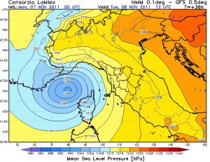
 As our resident weather expert has just written on the site – “Autumn 2001 never ceases to amaze. After the downpours, flooding and landslides of the 25th October and 4th November, now it would seem that the Mediterranean is just about to produce its own small hurricane – David Sesto”
Back in 2007 Reuters reported that ” Global warming could trigger hurricanes, or tropical cyclones, over the Mediterranean sea, threatening one of the world’s most densely populated coastal regions, according to European scientists.
Hurricanes currently form out in the tropical Atlantic and rarely reach Europe, but a new study shows a 3 degrees Celsius (5.4 degrees Fahrenheit) rise in average temperatures could set them off in the enclosed Mediterranean in future.”
Climate change models tailored to investigate some strange storms in the Mediterranean suggest that global warming could lead to hurricanes forming in that sea. If so, countries around the Mediterranean could be in for the most violent weather in centuries.
Most hurricanes form in the tropical Atlantic, rarely reaching Europe. But warming oceans could encourage them in the relatively landlocked Mediterranean, say the authors of a new study.
“It should be a matter of concern,” said Miguel Gaertner, a researcher at the University of Castilla-La Mancha in Toledo, Spain. “The consequences could be quite dangerous.”
Not only would European countries face more powerful storms, but much poorer countries in coastal northern Africa could be hit hard.
On rare occasions, tropical-like systems occur over the Mediterranean Sea. These systems are a subject of some debate within meteorological circles whether they closely fit the definition of tropical cyclones, subtropical cyclones, or polar lows. Their origins are typically non-tropical, and develop over open waters under strong, initially cold-core cyclones, similar to subtropical cyclones in the Atlantic Basin. Sea surface temperatures in late-August and early-September are quite high over the basin (+24/+28°C), though research indicates water temperatures of 20 °C/68 °F are normally required for development.
Meteorological literature documents that such systems occurred in September 1947, September 1969, January 1982, September 1983, and January 1995.[24] The last system developed a well-defined eye, and a ship recorded 85 mph (140 km/h) winds, along with an atmospheric pressure of 975 mbar. Although it had the structure of a tropical cyclone, it occurred over 61 °F (16 °C) water temperatures, suggesting it could have been a polar low. – Wikipedia
The idea of hurricanes hitting Europe and northern Africa is not completely farfetched, Gaertner points out, since in 2005 Hurricane Vince made an unprecedented landfall in Spain. What’s more, there was a remarkably hurricane-like storm with an eye in the Mediterranean in January 1995, which has been the subject of considerable study by climate and weather scientists.
“This storm looks very much like a small hurricane in satellite images,” reported MIT hurricane researcher Kerry Emanuel in 2005, in one of the first close examinations of the Mediterranean cyclone.
Usually the air is too dry and the pressure too high over the Mediterranean to create hurricane-like storms, according to Emanuel. But under the unusual conditions that created the 1995 storm — a low pressure system being cut off and and then pushed upwards over a warm sea — the Mediterranean can become an ideal “incubator” for hurricane-like storms
To see if this sort of atmospheric condition could become more common in a warmer world, Gaertner and his colleagues ran nine regional climate models nested inside global climate change models to see if any of them showed hurricane-conducive conditions developing in the Mediterranean.
Two 30-year runs for each model were done for the years 2071 to 2100. For a reality check, they ran the same tests on the years 1961 to 1990 to make sure the models were able to approximately reproduce history.
The team also used just one of many possible future greenhouse gas scenarios — that in which the release of greenhouse gases continues to increase. The models all included such factors as sea surface temperatures, humidity and wind shear, all of which can make or break a tropical cyclone.
“This is a very new study,” said Gaertner. “We used several regional climate models where others have used only one.” Their results appear in the latest issue of the journal Geophysical Research Letters.
What they discovered is that in most sensitive of their models there was, indeed, an increase in the formation of tropical cyclones in the Mediterranean. While Gaertner is concerned about the potential for hurricanes, he also stressed the preliminary nature of his study.
“There are several uncertainties,” Gaertner said. Future work should, for instance, include a range of greenhouse gas emission scenarios, which is what the Intergovernmental Panel on Climate Change does to assess different global warming futures. – source