 The following email arrived last week from a reader in the States.
I have a WWII aerial photo of Barga (20 February 1945) that I have not been able to place on Google Earth. It was left by my father who was with the USAAF. It shows an encampment with an arrow pointing to a building, presumably to be bombed. The photo also shows some bombed out buildings, fortifications, tents, haystacks, and possible trenches. There are a few roads that run through the photo.
Is there a local historical society that I could contact to find the location? Thank you, Bob Leith.
Full article is here but a week later and we were still no nearer to finding out any concrete information concerning these images then Il Giornale di Barga – the other news site in Barga also picked up on the story and passed the images on to a couple of historians in Barga.
All who looked at these images had doubts if they were taken over Barga as nobody managed to recognise any of the roads or features.
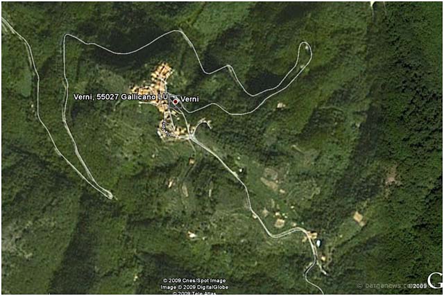
In stepped the photographer Ugo Borghesi who has many years of experience of ariel photography over the whole of this area and according to him the images are not from above Barga but further over in the valley above Verni in the comune of Gallicano.
He even produced an image from Google Earth to back up his claim .
So is he right ?
no images were found


Hard to say if Ugo is right about Verni — it doesn’t seem like a precise fit, but it wouldn’t after half a century. In any case, like a lot of people I’ve stared and stared at those WWII images, and they don’t remotely suggest either the terrain or urban structure of Barga, even as it must have appeared in the 1940s. What do other readers think?
La maggior parte dei soldati americani e dei cittadini non sanno dove e’ l’Iraq, figurati se riescono a distinguere barga o verni dall alto..
Ciao a tutti
Unfortunately, they were quite capable of locating Iraq. Getting out is the hard part. A bit like Italy in its love affair with Herr Hitler, during the war to which you allude.
1st Sergeant Charles Brown of the 370th Infantry Regiment states: “Upon reaching the town (Brucciano) we continued through it to the peaks on the north side. From our position beyond Brucciano, by looking over two little peaks we were staring right into the German position on another mountain.” (This action occurred on 18 November, 1944.) Google Earth confirms that this could be Verni.
Sergeant Willard Williams of the 366th states: “We had been given orders to make an attack upon what they called a hill outside of the town of Gallicano. When we hit that hill the Germans mowed us down like clay pigeons. I recall twelve or thirteen of us made it to the top uninjured. There was no doubt that we were pretty well mangled.” They were later forced to retreat from this position. (This action probably happened 5 February, 1945.) During this battle they were reinforced by the all black 332nd Fighter Group which strafed and provided air cover.
If it is Verni it was probably defended by the Brescia Alpine Battalion of the Italian Monte Rosa Division and reinforced by the German 285th Grenadier Regiment of the 148th Grenadier Division. There should be an Italian veteran from Monte Rosa or San Marco who would remember this encampment.
On the WWII aerial photo there appears to be an anti-tank trench 4.5 meters wide by 500 meters long, these trenches were usually 3 meters deep. At the end of this trench there was a bunkers 35 meters long. Some of these things must still be visible today.
Bob Leith